Initiative allows first responders and authorities to utilise grower location data to quickly plan protection zones in the event of a pest or disease incursion
A new A$1.7mn mapping initiative is set to change how fruit growers respond to biosecurity threats.
The initiative asks apricot, cherry, dried fruit, lychee, nectarine, peach and plum producers to log location data through an app to allow first responders and authorities to quickly plan protection zones during pest and disease incursions.
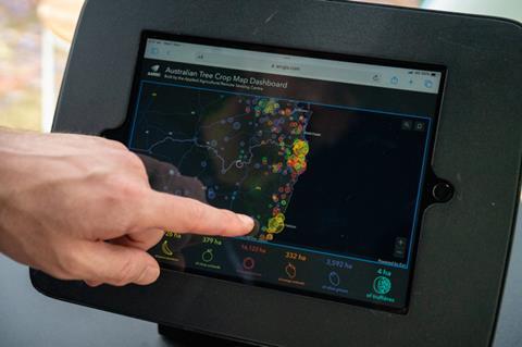
Delivered through Hort Innovation and led by the University of New England’s (UNE) Applied Agricultural Remote Sensing Centre (AARSC) in partnership with Future Food Systems CRC, the new tool marks an expansion of the Australian Tree Crop Map – a map which services eight tree crop industries and also boasts market access, traceability, yield forecasting, carbon storage, regeneration, and drought resilience applications.
Hort Innovation chief executive Brett Fifield emphasised the critical role of the map in supporting biosecurity preparedness and response.
“The Australian Tree Crop Map has repeatedly proven its worth, particularly in the face of biosecurity challenges like the Varroa Mite incursion,” said Fifield.
“With its ability to quickly pinpoint areas of concern, the map is an essential tool in managing biosecurity risks and equipping the industry with the timely data needed for an effective response.”
Cherry Growers Australia president Alison Jones said the map will be a game-changer for industry.
“Being part of the Australian Tree Crop Map provides cherry growers with vital data to not only manage production more effectively but also to stay ahead of potential biosecurity threats and mitigate their impact,” Jones said.
“This tool will ensure we are better prepared to tackle biosecurity challenges and respond swiftly to emerging risks.”
University of New England senior researcher Craig Shephard said the map is becoming a cornerstone for biosecurity monitoring.
“The Australian Tree Crop Map, created to Australian mapping standards and freely available for industry use, is rapidly advancing as a benchmark for industry-wide spatial data adoption. This data is critical for early biosecurity detection, risk assessment, and response coordination,” Shephard said.
“In this next phase, we’re expanding the map to include cherries, lychees, dried fruit, and summerfruit, while also enhancing it with additional data such as variety, planting date, and management practices for those fruits we already track such as mangoes. This will enable tailored biosecurity strategies for different industries.”
Australian Lychee Growers’ Association executive officer Jill Houser said the map will enhance biosecurity planning for lychee growers.
“Access to this comprehensive mapping resource will give lychee growers invaluable insights to better respond to biosecurity risks and other industry challenges,” Houser said.
“The data on crop trends and regional variations will help us make informed decisions, ensuring that we can protect our industry from both biosecurity threats and market shifts.”