USDA demonstrates food mapping tool
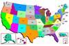
Officials have highlighted a new online food mapping tool as part of the recently launched Let's Move! campaign
You have now reached your article limit
Already a registered user or member? SIGN IN HERE
To continue reading, register today for free access Register now
Five reasons to register today

- Access selection of articles from our industry-leading magazines
- Regular newsletters to keep you on top of key developments
- Bookmark and retrieve your favourite articles
- Comment on stories and share your opinions
- Find out about special publications and events
Already a registered user or member? SIGN IN HERE