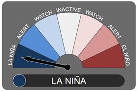
The Bureau of Meteorology has declared that La Niña has developed in the Pacific Ocean, upgrading from a La Niña alert status to an active event.
This means recent changes in ocean temperatures and weather patterns over the Pacific are now likely to remain until at least the end of the year.
La Niña is the cool phase of the El Niño Southern Oscillation. It is associated with cooler than average sea surface temperatures in the central and eastern tropical Pacific Ocean.
La Niña events often form in autumn or winter, then decay in late summer. The greatest impact normally occurs during the spring and early summer period. The events normally last for around a year, however the length can vary.
Recent observations and model forecasts by the Bureau show the central tropical Pacific Ocean is now 0.8°C cooler than normal, and that has resulted in changes to Trade Winds and pressure patterns. Climate models suggest these patterns will continue until at least the end of the year.
La Niña typically results in above-average spring rainfall for Australia, particularly across eastern, central and northern regions. It can also mean cooler days, more tropical cyclones, and an earlier onset of the first rains of the wet season across the north.
The last La Niña event occurred from 2010-2012 and resulted in one of Australia’s wettest two-year periods on record. Widespread flooding occurred in many parts of Australia associated with the record rainfalls.
The impacts of La Niña can vary significantly between events. It is likely this year will not see the same intensity as the 2010-11 La Niña event, but is still likely to be of moderate strength.
In the south-east, Tasmania, Victoria, South Australia and New South Wales typically have wetter than average conditions in La Niña years. Therefore, the Bureau is predicting above-average rainfall for the whole south-east region. The eastern most parts of the south-west may see above-average rainfall.
In the north-west, there is an increased potential for more tropical cyclones during La Niña.
Above average rainfall is likely in the Kimberly and the Top End.
The north-east, including northern NSW and all of Queensland should see above-average rainfall with a potential for increased flooding.
The potential for more tropical cyclones crossing the coast increases in the far north-east during La Niña events.